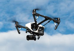
Albuquerque, New Mexico’s Municipal Development Department has begun using drones to ensure the state’s roads, bridges, and dams are safe. According to a story on KRQE, specialized software allows the drone to view bridges and streets differently than the view surveyors had in the past, showing the depth and topography of the area.
Johnny Chandler, a department spokesperson, told KRQE that the drone takes a “3D survey of the road” and is also “able to let you know what happening underground as well.” The article goes on to describe it as a “far cry” from what an average drone would show.
On Monday, the team surveyed a road that they thought might be sinking at Albuquerque’s Balloon Fiesta Park. With the drone, the large area can be surveyed in a week without any, or minimal, road closures. The conventional way would take a month, and cause traffic disruption.
"The idea behind this drone is to streamline the process, to be a little less intrusive to the community and we're going to do as many as we can," Chandler told KRQE.
Source: KRQE
