Trimble details autonomous soil compactor at Dimensions
Some 4,000 attendees from 50 countries opened the latest edition of Trimble Dimensions in Las Vegas, the tech company’s user conference that features 450 learning sessions related to Trimble products and putting them into practice across various industries.
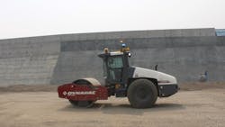
There has been a notable advance in the company’s autonomous ambitions that were on display at last year’s event. Trimble announced it has completed its first test of a fully autonomous soil compactor on a live job site.
The Trimble Earthworks Grade Control Platform for Autonomous Compactors was installed on a Dynapac CA 5000 soil compactor and tested on the Site C Clean Energy Project at the Peace River in Northeast British Columbia, Canada.
The Dynapac compactor completed 37 hours of work alongside a mixed fleet of rollers running the Trimble CCS900 Compaction Control system. All the data from the machines was delivered using the company’s WorksOS software, which recorded all the compaction data from the site.
Read also: Top combination rollers of 2023
The Site C Clean Energy Project is a BC Hydro hydroelectric dam. When complete, it will provide 1,100 megawatts of electricity each year, enough to power 450,000 homes or 1.7 million electric vehicles. Prime contractors include ACCIONA Infrastructure Canada and Samsung C&T Canada Ltd., among others. The role of ACCIONA and Samsung includes construction of an earthfill dam, two diversion tunnels, and a roller-compacted concrete foundation for the generating station and spillways.
Trimble says testing will run into 2024 before the platform begins beta testing with select customers.
“This is just the first step in what will be a diligent and careful testing process, but it’s an important step and we are highly encouraged by the results,” says Aaron Thompson, VP, autonomous solutions, for Trimble.
Trimble, Skydio partner to streamline infrastructure workflows
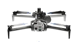
Trimble and autonomous drone provider Skydio revealed a new integration to help construction and utility companies, as well as state transportation agencies, to streamline workflows for greater precision and project efficiency.
This collaboration will enable customers to benefit from centimeter-level accuracy in survey and mapping projects through the precise data capture, visualization, and analytics enabled by Skydio autonomous drones integrated with Trimble GNSS receivers and software.
By capturing images and geospatial data early and often throughout construction projects, organizations can more easily ensure on-site work matches the design and reduce costly rework, which for the average project can easily be 4 to 6% of the overall construction cost, according to Skydio. When bridge or utility site inspections need to scale, using the Skydio and Trimble integration is meant to deliver the comprehensive data and workflow needed to identify issues early and take action to prevent failures.
"Incorporating Skydio into our ecosystem augments our platform's capabilities, offering our customers a fully integrated, end-to-end workflow from data acquisition to analytics," said Aviad Almagor, VP of technology innovation at Trimble, in a statement. “Our customers are seeking such automated workflows to handle the vast amount of data and maximize its value through improved production and quality control processes.”
The collaboration will allow:
- Automated Data Integration: An automated, API-based integration enables seamless transfer of drone-captured imagery and metadata from Skydio Cloud to Trimble Industry Cloud. This integration accelerates the conversion of reality-capture data into actionable insights that enable more efficient and shorter decision-making processes. Further refinement and analysis of the output data can be carried out in professional surveying and mapping environments such as Trimble Business Center (TBC).
- Survey-Grade Accuracy with Skydio X10: Skydio's flagship X10 drone with the RTK GPS attachment will be fully compatible with Trimble's GNSS receivers, enabling mutual customers to achieve survey-grade accuracy in mapping missions when employing Skydio alongside Trimble's base stations and GNSS receivers. Beyond RTK, customers will also be able to conduct PPK based corrections post-flight.
Trimble MPS566 GNSS receiver
Trimble also released its next generation GNSS receiver for drilling and piling operations and marine construction and—the MPS566 Modular GNSS heading receiver.
With built-in dual GNSS antenna ports and constellation-agnostic Trimble ProPoint technology, the MPS566 is designed to deliver accurate positions and orientation for work that demands precise heading. It consumes low power and has minimal cabling, all benefits when installation space is at a premium, the company says.
The MPS566 is also fully compatible with the Trimble Groundworks Machine Control System, allowing operators to obtain precise locations for more accurate drilling and piling, even when GNSS multipath interference is present. This is particularly beneficial, Trimble says, for meeting the accuracy and positioning requirements for renewable energy construction projects, including solar farms.
Also, Trimble and Ferguson today announced that Ferguson locations nationwide have joined the Trimble Supplier Xchange digital pricing and procurement network, further digitizing the construction supply chain for mutual mechanical and commercial customers to increase efficiency between construction teams and their most important business relationships.Trimble released some charitable news, as well. Trimble and the Trimble Foundation Fund have partnered with The HALO Trust, the world’s largest landmine-clearing non-profit organization, to help expand its demining operations across Ukraine.
The Foundation Fund directed grant focuses on strengthening the HALO Trust’s capacity to locate and remove landmines, unexploded ordnance, and other explosive hazards from civilian areas.
About the Author
Frank Raczon
Raczon’s writing career spans nearly 25 years, including magazine publishing and public relations work with some of the industry’s major equipment manufacturers. He has won numerous awards in his career, including nods from the Construction Writers Association, the Association of Equipment Manufacturers, and BtoB magazine. He is responsible for the magazine's Buying Files.


