Out there somewhere could be an earthmoving contractor who has invested in GPS and, for some reason, is not happy with his decision. But it's unlikely. Construction Equipment has talked to a fair number of GPS-using contractors in the past few months, and their reports, frankly, are almost embarrassingly positive.
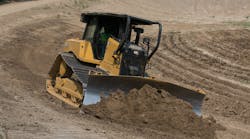
Consider, for example, the experience of Southgate Constructors, Charlottle, N.C. According to Tom DiGiampaolo, operations manager, an operator on the company's Cat D6M was grading two building pads per day following stakes. But after fitting the machine with an automated GPS system, the operator cuts six pads per day, minimum, with no stakes and no rework. The increase in production was complemented, says DiGiampaolo, by a significant reduction in surveying costs.
"If we were grading a 100-lot subdivision in the conventional way," he says, "we might have in excess of 2,000 stakes and pay $120,000 to $130,000 in total surveying costs. But restaking is the real killer, especially if you have to pay travel time for the survey crew."
Working on a site with virtually no stakes can be disconcerting at first, says Brad Heavner, vice president and operations manager for Scurry Construction, Cornelius, N.C. But, says owner Bill Scurry, the company has gained confidence in the grade-control ability of its GPS-equipped Cat D6M dozer and Deere 450 excavator. A recent 100-acre, site-development job entailed moving one million cubic yards of dirt, he says, and essentially no stakes were used in the cut and fill areas.
Rob Mills, Teichert Construction, says that grading the complicated contours for golf-course greens in pre-GPS days involved perhaps two or three grade setters and several pieces of equipment.
"Now," says Mills, "we have everything we need in one GPS dozer. That means we save the cost of the grade setters and the cost of the finish blade. If you use GPS in the right applications, and you're creative with it, you can save yourself a lot of money."
According to Mills, GPS also has given the company a new measure of "versatility."
"Before GPS," he says, "a foreman usually had his entire crew working in one specific area. Now he can be more versatile, because he can send a dozer or a blade with machine control to one spot to work alone, while he uses his other resources elsewhere on the job."
Jim Lineberger, president of Lineberger Grading, Lancaster, S.C., has four machines working with machine-control. A GPS-equipped scraper, he says, works with the pack until within a foot of grade, then works alone to prevent undercutting or overfilling, and the subsequent rework that would entail.
Don Ahmer is what the industry calls an "early adopter of technology." Fifteen years ago he began using laser-equipped mid-size dozers, with an automatic electronic/hydraulic interface, to finish building pads that had been roughed in by a larger dozer. After discovering GPS, though, he soon found that one of his Cat D8s could grade accurately enough, without stakes, that the laser machine was no longer required.
"We saved $40,000 on that first GPS job," says Ahmer, "and savings have been accruing ever since."
Louis Avila, L & K Equipment, has only one machine, a Caterpillar 14G motor grader, but decided two years ago to fit it with an automated GPS system. His machine usually arrives on the site, he says, after dozers have taken cuts down to half a foot or so.
"With GPS," says Avila, "I think the machine is 30 percent more productive, and that's a conservative estimate. You're making a lot fewer passes with GPS. And, you don't need a grade checker. I think that eliminating the grade checker, alone, has paid for our system."
And, GPS is helping contractor Tony Nyen, Nyen Excavating, avoid a frequent end-of-job liability—finger pointing.
"Before installing our first GPS system in 2000," says Nyen, "we frequently had 'grade issues' with engineers and developers who questioned our work. That's when the finger pointing started. Who was at fault? Us? The surveyor? The engineer? The stake setter? That all stopped, though, when we began grading with a GPS dozer. Now we come onto the site, do the grading in one shot, and move on to the next job. We don't move dirt twice anymore."
Not moving dirt twice, he says, is the reason his company's billings doubled in the year after investing in GPS.
The future of GPS earthmovingAlthough the NAVSTAR constellation has been fully operational since 1994, it continues to be in an active state of refurbishment and modernization. The satellites now in use have been launched between 1989 and 1997, and the Department of Defense, in 1998, released a "modernization" plan aimed at enhancing the capabilities of the constellation. Part of the plan is the addition of two new civilian signals from the satellites, one called L2C, the other, L5.
The first satellite to broadcast the L2C signal is scheduled for launch in 2004. The L2C signal, basically, will enhance the real-time-kinematic (RTK) capability of new receivers. The L5 signal is designed to facilitate acquiring and tracking weak signals. Satellites capable of broadcasting the L5 signal are scheduled for launch in 2006.
Concerning the GLONASS constellation, the Russian Aviation and Space Agency, Rosaviakosmos, announced in January that it would launch three additional satellites in 2004. According to the Russian Itar-Tass News Agency, the government's goal is "to have its own fully-fledged GLONASS constellation of 16–18 satellites by 2005."
Also according to the news agency, the European Space Agency and Rosaviakosmos have agreed to use GLONASS satellites to test equipment for use in the European Community's proposed GALILEO constellation. Says Itar-Tass, "in expert opinion, the eventual merging of the GLONASS and GALILEO resources is not ruled out, in order to form a single global system."
Other experts, however, are debating the issue of "interoperability," that is, how well GALILEO will work with the NAVSTAR and GLONASS constellations. Some experts welcome the prospect of more satellites and their potential, positive effect on satellite-based positioning systems. One such is Jim Doherty, senior analyst, Institute for Defense Analysis member, Independent Assessment Team.
"On the question of interoperability between GPS and GALILEO," says Doherty, "the overwhelming operational issue is that geometry matters. For better geometry, particularly in urban and natural canyons, mountainous terrain, and other challenging situations with limited views of the sky, the more signals available from different satellites, the better."
This discussion aside, satellite-based positioning systems will assuredly continue to advance technically in order to capitalize on all new developments. The anticipated results are greater accuracy and flexibility. It's been said that GPS is becoming a "utility," a resource, like electricity, that pervades every-day activities in numerous ways.
All of this bodes well for satellite-based machine-control and grade-management systems on earthmoving sites.
Says Louis Avila: "There's no doubt in my mind that this is the way all jobs will be done in the future."


