MaineDOT Uses GPR for Pavement Evaluation
The State of Maine Department of Transportation is at the forefront of research on how to improve road pavement quality and extend service life. It focuses on improving both the material mixes used and how they are put down in the field. One recent addition is the use of GSSI’s PaveScan RDM, which can accurately measure whether there is density uniformity throughout the pavement layer.
Studies have found that optimum pavement density is a crucial factor in increasing pavement life. Pilot tests on about a dozen projects show promising results; researchers believe the equipment will be a powerful tool to help contractors make adjustments to ensure pavement quality.
Sommerfeldt is application specialist, road and bridges, for GSSI
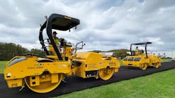
MaineDOT does the most it can to make sure the material is applied properly in the field. It specifies the equipment contractors must have, for example, material transfer vehicles (MTVs), which ensure a more uniform and longer lasting road surface. They also include ride smoothness specifications to cut down on the undulations that would eventually lead to road-performance issues. Also included are specifications for joints; thermal profiling with an infrared (IR) scanner; and use of intelligent compaction (IC) rollers, which facilitate real-time compaction monitoring and timely adjustments to the compaction process by integrating measurement, documentation, and control systems.
“We began implementing quality control/quality assurance (QC/QA) practices years ago, and we have trained and certified technicians sampling material on the roadway,” said Dale Peabody, director of the transportation research division at MaineDOT. “It’s a continuous process, in which we have gone away from fixing the worst first to aggressive preservation practices. It’s just like how drivers don’t wait until a car breaks down before changing the oil.”
According to Peabody, optimum pavement density is the crucial factor in increasing pavement life. “Optimum density reduces oxidation, reduces moisture damage, and decreases rutting potential. It also offers improved fatigue life and increased load bearing capacity.” He cites past studies relating density to pavement life – the rule of thumb is that even a 1 percent decrease below minimum density results in a 10 percent loss of pavement life.
In the past, Maine has used nuclear density gauges to measure density but has moved away from this type of technology. Contractors now use a non-nuclear asphalt density gauge for QC purposes and cores are collected sent to a lab to determine voids/density acceptance. “The down side of cores is limited sampling and not having real time values.”
The issue of pavement density has been extensively researched as part of the Federal Highway Administration’s Strategic Highway Research Program (SHRP2). SHRP2 eventually came up with two non-destructive techniques for evaluating asphalt pavements during construction: infrared thermal scanning and the use of ground-penetrating radar (GPR), which uses electromagnetic wave reflection to “see” through materials.
According to SHRP2 studies, GPR can be used to measure uniformity and potential defect areas in asphalt pavements during construction. Significantly, it offers real-time testing of potentially 100 percent of the pavement area. Compare that to current density tests, in which typical random sampling measures only about 0.003 percent of pavement area.
In 2013, SHRP2 funded work aimed at developing a streamlined and operator-friendly GPR device that would provide real time profiling of asphalt mixture uniformity. The research was done by the Texas Transportation Institute (TTI), which worked with GSSI to develop the technology into the PaveScan RDM asphalt density assessment system. The non-contact PaveScan RDM technology uses a sensor that typically outputs a measurement each half-foot along the lane traveled, so a mile’s worth of data includes roughly 10,000 measurements for each sensor used. This system is ideal for uncovering inconsistencies that occur during the paving process, including poor uniformity and significant variations in density.
To arrive at pavement density, PaveScan RDM measures the dielectric properties of the asphalt surface. The dielectric constant is the ability of a substance to store electrical energy in an electric field. For example, air dielectric is 1.00059; asphalt aggregate is about 3 to 6; while the dielectric of water is 80. With new pavement, the mixture is uniform; dielectric variation occurs primarily due to the percentage of air voids – which directly correlates to density. The measurement is based on the ratio of reflection from the asphalt surface to the reflection from a metal plate.
On the road in Maine
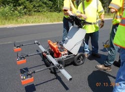
Maine is one of several states that have conducted pilot studies using PaveScan RDM equipment. The PaveScan RDM uses one or three 2-GHz sensors mounted on a portable push cart that can scan a of up to a 6-foot width. Each antenna collects a continuous line of dielectric/density. An onboard computer captures dielectric values, which can be correlated to core densities. Operators scan a pavement section and the device identifies high, low, and median density locations. They take a static reading directly over each location, obtain cores at each location, and then test the cores, entering the results in the software. Correlation accuracy depends on obtaining core densities over the entire range of measured dielectric values.
To date, Maine DOT has collected data on about a dozen recent paving projects and found that the data aligns well with what they have seen in the field.
“We were looking for a better way to ensure we’re achieving desired density ranges, since studies show that good density leads to improved service life,” Peabody says. “PaveScan RDM gives a much larger sample of the HMA mat and can be used as a QC/QA tool. The results to date have been really positive.”
It helped that Maine DOT had a crew that was already familiar with GPR, making it a relatively easy transition to get up to speed. The crew found the PaveScan RDM equipment to be easy to set up and use. The only limitation they found is that the battery does not last long enough for a full day of data collection. Other recent adjustments include a laser pointer that can be attached to the equipment to help operators align the scanning equipment, especially for use in night work. Operators found the extra lighting to be very helpful.
However, Peabody notes that the technology does have some boundaries. It is affected by surface moisture, does not work as well when temperatures dip below 40 F, and can be affected by mix constituents, which may happen with a change in aggregate source. Measurement accuracy for layers of less than 1-inch may be affected by the underlying layer, while layers that are 2.5 to 3-inches may be affected by density gradients within the layer.
Maine DOT is also looking for further enhancements. For example, some users are adapting the technology for use with vehicle mounts. This issue is one that GSSI is actively pursuing for Spring 2019. Other items on the wish list are better ways of using the technology for longitudinal joints; incorporation into the Veta intelligent construction software – a map-based tool for viewing and analyzing geospatial data; and better data analysis of intelligent compaction, thermal profile, and GPR density data.
Data analysis
Although not unique to this technology, one of the key factors affecting whether Maine DOT would want to implement the technology statewide is the issue of data analysis.
“Who is going to collect all this data?” asks Peabody. “If there are 20 projects, you can’t have just one crew collecting data. We have thought about asking the contractor to purchase the equipment and use it but we are not ready for that, because for it to work you have to have people who really understand the technology.”
Ultimately, he says it would be best if this type of data could be collected in a moving vehicle; the vehicle could then go project to project and collect data.
However, Peabody acknowledges that this approach would have a downside – the lack of real time data contractors could use to make adjustments as they are going along. “If they collect data but don’t look at it until the next day, that does not really give the contractor a chance to make adjustments if there are density issues. I’d like a way to share data with the project team in real time, other than only being able to show the display on the Toughpad.”
According to Peabody, the larger question that must be answered is how to effectively manage the data to make near-real time changes during production, and to get timely reports to project personnel. “Currently, there is no good way to get data in the right people’s hands so they can make adjustments on the fly. There is a lot of benefit to having that ability. They could collect data and then go back to specific points on the road. They could select locations of high and low dielectric/density and then cut a core there and send it to the lab to determine the actual density.”
The PaveScan RDM surveys show a good correlation between the dielectric value and the air void contents. MaineDOT can use the surveys to quickly identify and investigate low density areas and to check the compaction consistency. Although data management is a huge effort, officials say the surveys will be useful, in conjunction with other new technologies, including intelligent compaction and pave IR.


